Essential Geometry Validation
Products
Essential Geometry Validation
Preparing for a data migration project? Thinking about Digital Twins? Establishing a data quality baseline is a crucial first stage of any project where you are looking to unlock the value of your location data.

Easily validate your geospatial data against common OGC Standards
The Open Geospatial Consortium (OGC) is an international consortium who work to create royalty free, publicly available, open geospatial standards. Their goal is to make geospatial (location) information and services Findable, Accessible, Interoperable, and Reusable (FAIR).
Ensuring your data aligns with common OGC standards is a great way to ensure consistency, increase data quality and improve your data interoperability.
Essential Geometry Checks
Upload your data to our Essential Geometry Validator and in no time at all you’ll have a clear and concise report detailing how well your data performs in our 10 essential data check categories:
|
|
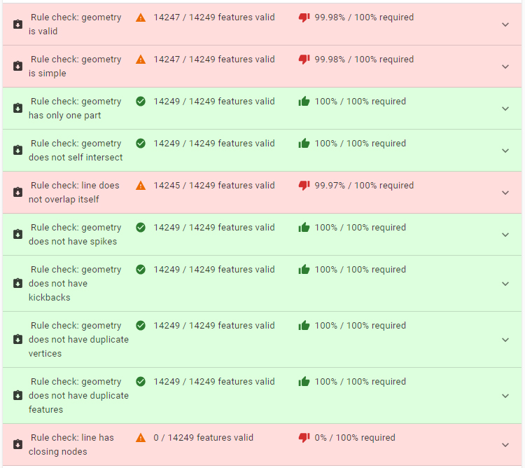
Each category performs multiple checks to ensure your data is as robust as possible. “Valid” might sound vague, but under the hood our rules engine is actually checking a comprehensive list of criteria to ensure your data is the best it can be.
For example, the criteria for features passing as valid are:
- Clear geometries are invalid (no geometric data).
- A simple-point or complex-point geometry is valid.
- A simple-line geometry is valid if it has at least two points and no adjacent duplicate vertices.
A simple-area geometry is valid if:
|
|
Note:
- 3D geometries are currently validated using SFCGAL rules.
- A complex geometry of a single or mixed type is valid if each component is valid.
Features
1Data Gateway for ArcGIS Pro
Put your data to the test against our Essential Geometry Checks using our Esri ArcGIS Pro add-in to quickly identify common issues, directly within your editing environment.
Contact us
Contact an Essential Geometry Validation specialist for more information or a detailed product demonstration.
Contact us